The national juries drew up a shortlist of proposals between July & October 2015. These jury sessions were followed by a European comparative analysis of the shortlisted ideas, which took place at the Forum of Cities and Juries held on Nov. 6th and 7th, 2015, in Bratislava, Slovakia. The final selection of the winning projects by the national juries was done in November.
The wide diversity developed in the winning projects presents urban/architectural spaces allowing new ways of sharing collective space and governance methods requiring a chronotypical approach, blending the spatial and temporal dimensions. They propose a sensitive form of urban planning, where different places can be used at different times, and rethink the quality of the spaces from that perspective, raising the question of the “hospitality” of urban spaces and their appropriation by city users. Many of them introduce intensive development projects, even in many different contexts, to better connect them with the realities of the contemporary city.
Below we present all winning submissions for EUROPAN 13 competition:
DEUTSCHLAND
BAMBERG

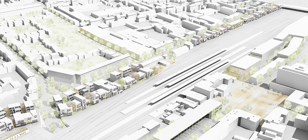
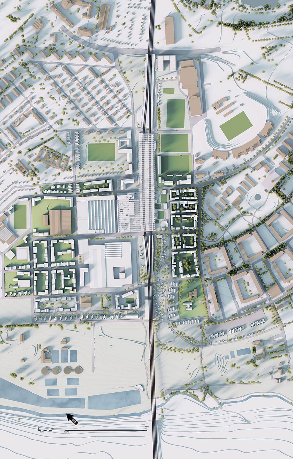
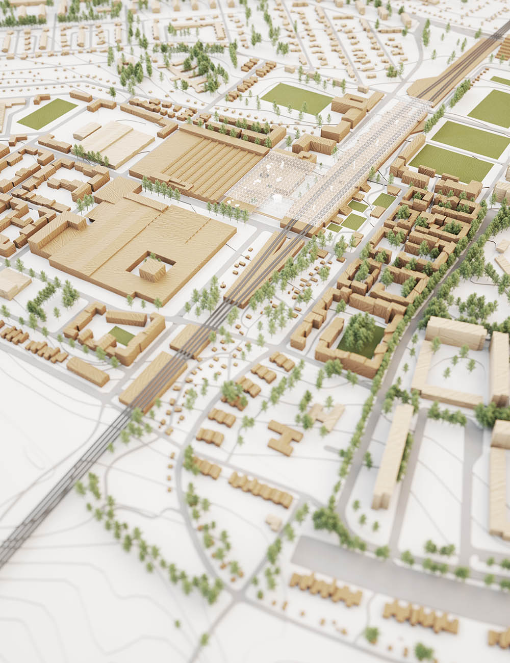
The eastern parts of Bamberg are divided from the western parts, which partly consist of the UNESCO World Heritage, by a wide area of railway tracks. In addition there is a large barracks site in the east which will be converted into a residential area soon.
The present design proposes a network of new and existing public spaces and connecting cycle-/ footpathes between the barracks, the adjacent green space of Hauptsmoorwald and the inner city. In combination with new public squares there are arranged small neighbourhoods with different levels of privateness.
Within the design proposal special attention is laid on the area along the railway tracks. On the one hand the merging of Bamberg is strenghtened by the renovation and widening of the tunnel of Zollnerstraße and by a new direct cycle tunnel starting each in the new bicycle parking house and in the railway station. On the other hand there are designed new buildings along the railway tracks which adapt and represent the Bamberg traditions of the gardener culture and the baroque style.
The baroque principles of overlapping, plasticity and the moving observer are translated into contemporary forms. Planted atriums and vertically greened walls are a reference on the gardener culture. Office buildings and parking garages are arranged close to the railway tracks as an acoustic noise barrier for the adjacent new and existing residential buildings. The design shows how to adapt traditions and to connect it to a subtle network.
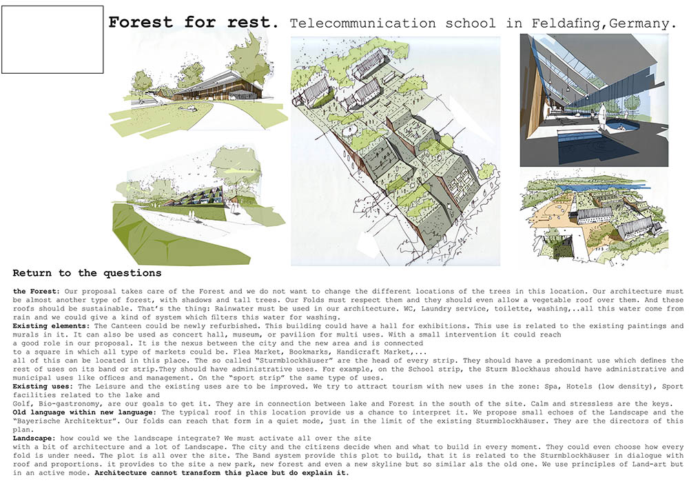
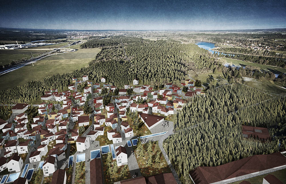
FELDAFING
Project by: Pablo ALLEN & Elisabeth GARCIA ASENSIO
“ Forest for Rest ”

GERA
The large buildings like the Gera arcades, the KuK or massive precast buildings are opposed to a new architecture design that divides the district at the Breitscheidstraße in small plots. At these plots different design elements and using structures shall be combined in the future. The setting of a new lighting system guides people from the shopping street Die Sorge into the new quarter.
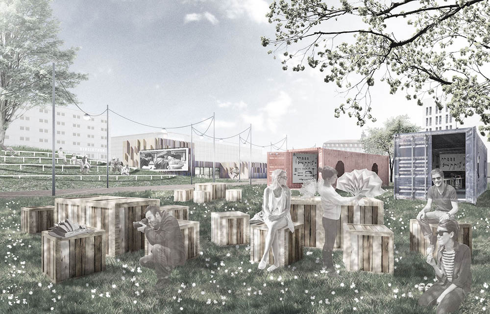
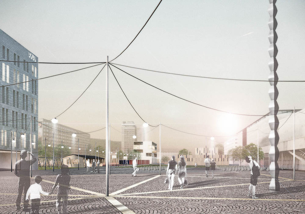
Since the city of Gera has a limited budget for investing into the urban development, the concept of the project Colonization of the city center is based on the possibility to develop the quarter in sections. In order to initiate a strategy for a revitalizing of the site that is accompanied and supported step by step by the population, it is planned to develop the plot in several construction phases. The project just shows a rst step of development, not a completely finished version. In the beginning the area is marked by a few architectural structures, which serve as an orientation to create the area in a new way. A hotel with commercial spaces on the ground floor, a youth center with an adjacent sports and skate park and a residential complex with private gardens will be introduced right away. These basic architectures are connected by a footpath with a new lighting system. In the first phase temporary uses supplement the basic architecture and offer the possibility of a low-cost upgrade of the entire area. Micro architecture such as container garages, private gardens, playgrounds, a reading / theatre stage and a beer garden complete the proposal. A new lighting system extends over the entire area and connects die Sorge with the museum square. On the day it is possible to attach pictures, banners, pennants, flowers etc.. At night several light bulbs illuminate the area.
In the future there will be different possibilities for the development of the quarter at Breidscheidstraße.The following scenarios present two contrasting ways of progress.
Scenario 1
Establishment of temporary uses:
The temporary usage is acceptable to the population so that it persists in the long term and will be further developed. As a role model for other cities Gera receives funding to regularly change the temporary microarchitecture for a vital sustainability.
Scenario 2
agglomeration:
An economic boom in the city of Gera with an increased need for more commercial – and residential spaces causes an agglomeration in the quarter. In addition to the basic architectural structures arise other buildings that strengthen the city center and complement diversity.
INGOLSTADT
Project by: Gonzalo GUTIERREZ, Alvaro CARRILLO EGUILAZ, Adrià ESCOLANO FERRER
LANDSBERG
“ Living With(In) Nature ”

The approach to the site required time and study due to the complexity and the richness of its surroundings. The area is located between natural-artificial elements on all sides. We came to the conclusion that the center, both conceptually and geographically, of these opposing elements is exactly the project site. Therefore the proposal had not just to give answer to the residential demand, but also to an harmonious integration with these elements. Defining a landscape front to the new area; creating the right relation between an industrial environment and a comunity and naturalistic one. Integrating in a real way both the natural and the human enviroment.
The new buildings develop as they would flow from the new front , with a standard density at the beginning and then shading as they approach to the forest. In this way residential, cultural and every day facilities are properly spreaded in the site. The north-south roads are for cycling and walking use mainly to make this “in beetween” streets the main comunitary open spaces for the social needs of inhabitants. Inverserly, on the other side the green of the forest does the same, getting inside the site and fading as it gets closer to the industry. The structure and the organization of this new living area will consist with a balance of nature and artificial elements, creating an enviroment with very different and unique features that works in sinergy with the deeply and strongly urban enviroment of the town of Landsberg.
MARL
SELB
SPAIN
A CORUÑA
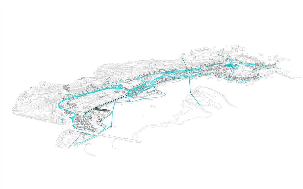
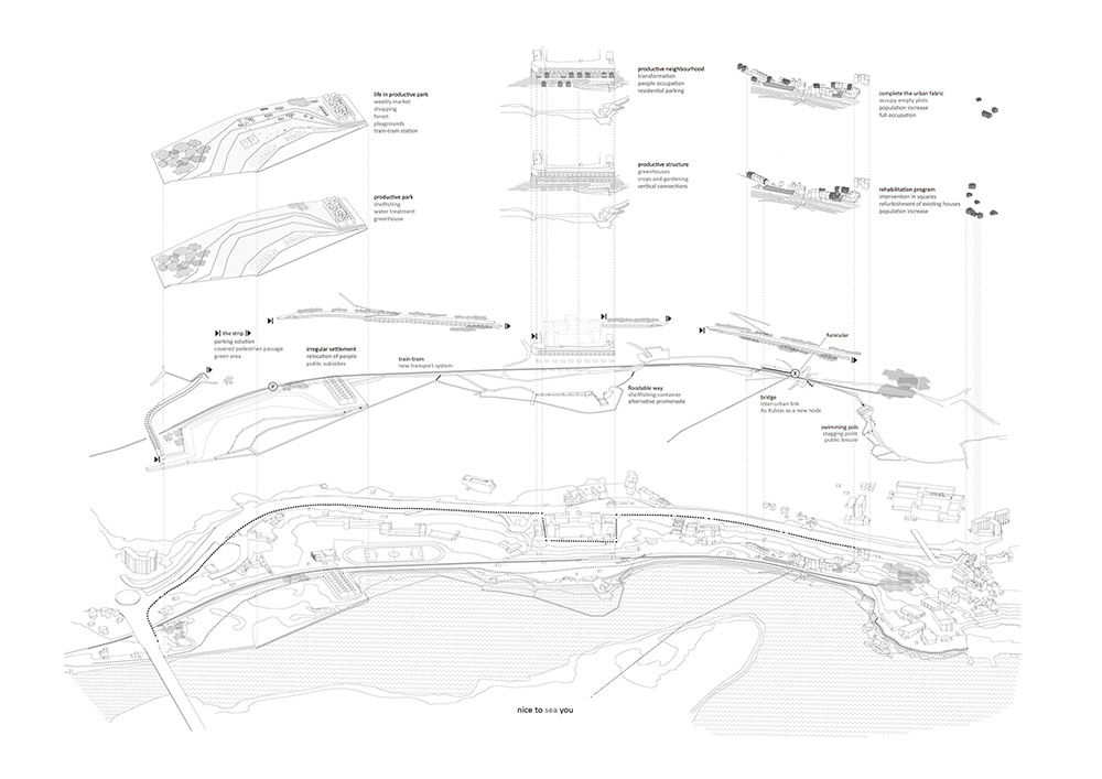
Nice to sea you is an activation program with public and private initiatives. It´s focused in a sphere of actuation which contains two neighborhoods: As Xubias and A Pasaxe with the 2% of the city population. Itwill convert the area in a productive neighborhood.
The area, where the sanitary buildings are placed without sense, is defined by an abrupt topography and three lines: highway, train-tram and the water border. This space of opportunity is a coastal ecosystem with good capabilities for crops and a peri-urban field between growing urban areas.
Interconnected phases are based in a needed step: public initiatives about enhancing public transports and a strip to solve the highway border and the traffic and parking problems.
This activation program is started by some primary operations: the bridge to Santa Cristina as a new urban link, the new train-tram public transport with stations both at the new park and square, several transversal connections, a new incentive parking… These measures will transform As Xubias in a free-car new urban node.
Public subsidies will improve the housing conditions and attract population at the same time the irregular settlement will be relocated. Building is associated to production, greenhouses, ground cultivation and shellfishing .
The productive park in A Pasaxe is the space for new events, where the restored building is a new activity focus. The border line is transformed in a water treatment pond, where the sea loch approaching is more pleasant.
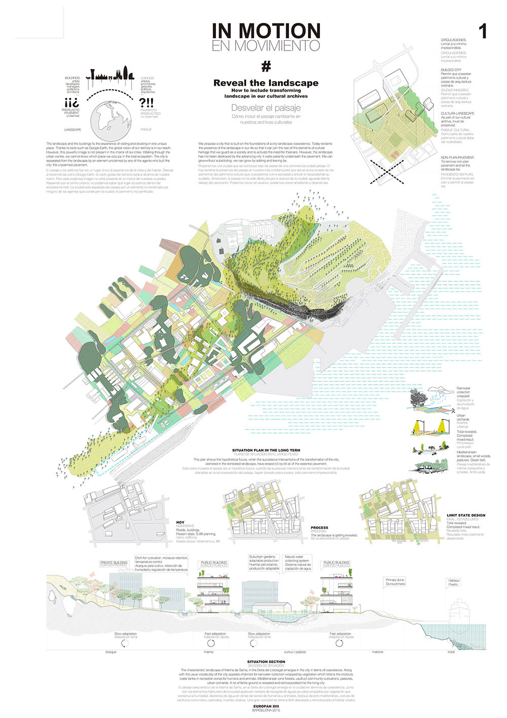
BARCELONA

PALMA
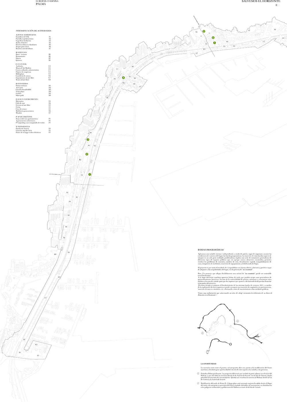
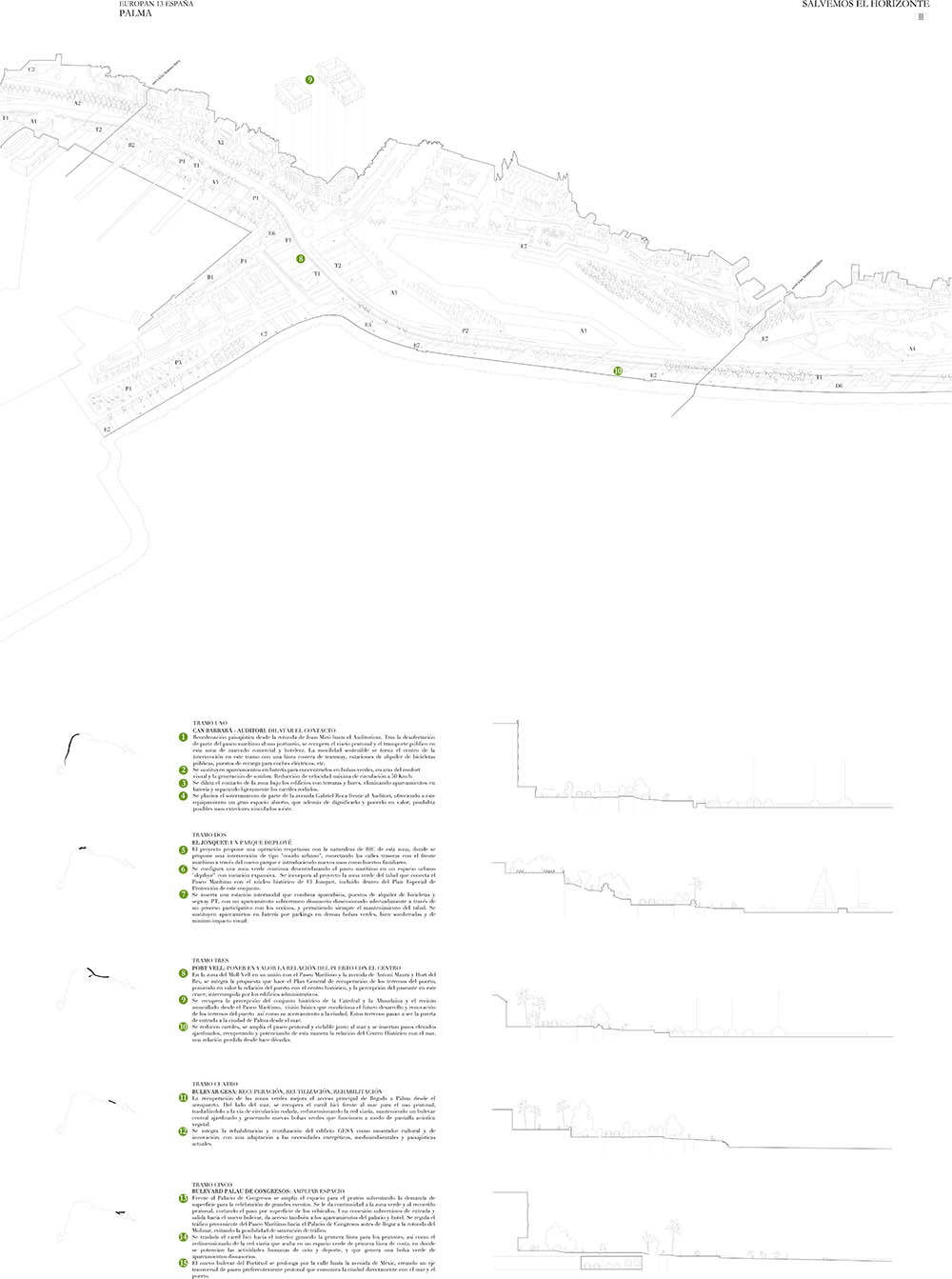
The project is in fact the result of making compatible an open system, abstract and generic capable of adapting itself to the singularities of the site and the premise of “no construction”.
How would a vessel crossing an area of swell find a reference of line of flotation in the horizon?
THE OPPORTUNITY IS NOW
The north connexion between the harbour and the airport gives the opportunity for the requalification of the sea front and brings the great opportunity to return this space to the city and its people. Entrance to Palma by the East. The proposal differentiates in one end the urban area with the beginning of the Bulevar and on the other end a direct connexion of the eastern motorway with the Via de Cintura giving priority to the itinerary of the bypass. The result is an access to the Molinar via the Via de Cintura and the Autovía de Levante. Changes to the node of Porto Pi. In the long term it will be necessary to improve the exit from the western dike to the motorway in foresight of the future changes in traffic of merchandises and its distribution to the industrial areas and towns of Mallorca via the Via de Cintura.
FRANCE
BONDY
GOUSSAINVILLE
LA CORRÈZE
MARNE-LA-VALLÉE
METZ
MOULINS
“ La théorie de l’évolution – Moulins entre évolutionnisme et transformisme ”
SAINT-BRIEUC
Project by: Iris CHERVET

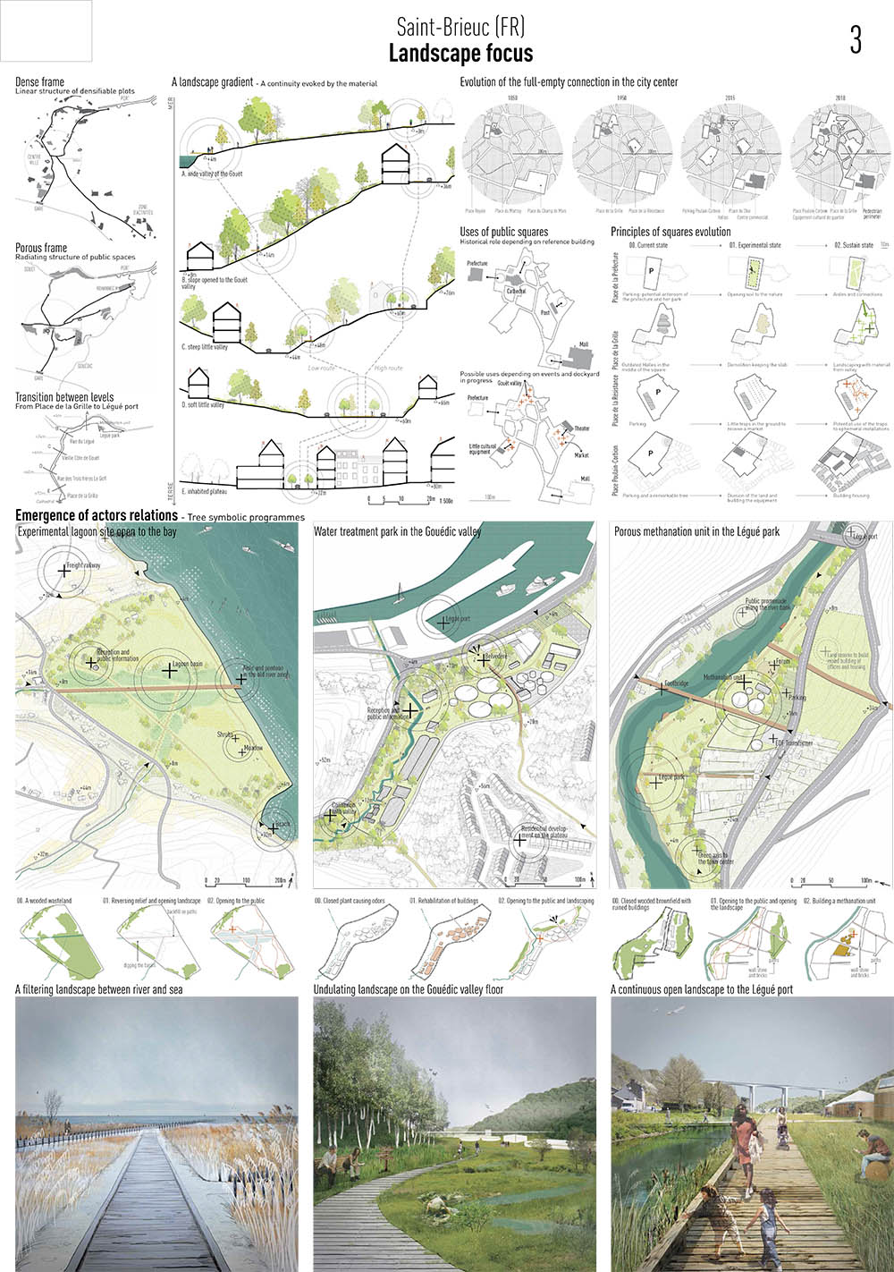
SAINT-BRIEUC
VERNON
CROATIA
ZAGREB


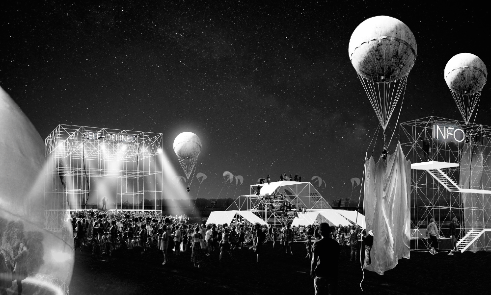
Expanding into the vast urban/suburban territories of Zagreb, Sava River runs through approximately 20 km adjacent to the city. Aiming to reintroduce the riverside to its inhabitants, the project examines four underused but critical sites and focus on the question of how intervention on four separate sites can have holistic effect to change movements and relationships of the entire river with the city. The project stands as an exploration of opportunities to experiment the effect of relatively small, soft and temporal interventions that are characterized by dynamism, immateriality, and indeterminacy. Therefore, the proposal introduces a framework of negotiation in which a constant conversation of the sites/their surroundings/programs is promoted through movement and exchange on/around the water. As the medium of this exchange, activator structures will be swapped/interchanged between the sites enhancing the east-west connection of the city through river.
Consisting of nine structures with different roles and capabilities, the activators are pivotal for negotiation of programs, activities and goods in between the sites. By visiting each site and being carried through water, the activators foster conversation between the sites, convey programs from one to another, and adapt to the needs of the sites. While every single structure is able to host multiple activities through slight changes, combination of varying number of activators generate endless possibilities of events and uses.
ITALY
MOLFETTA
KOSOVO
GJAKOVA
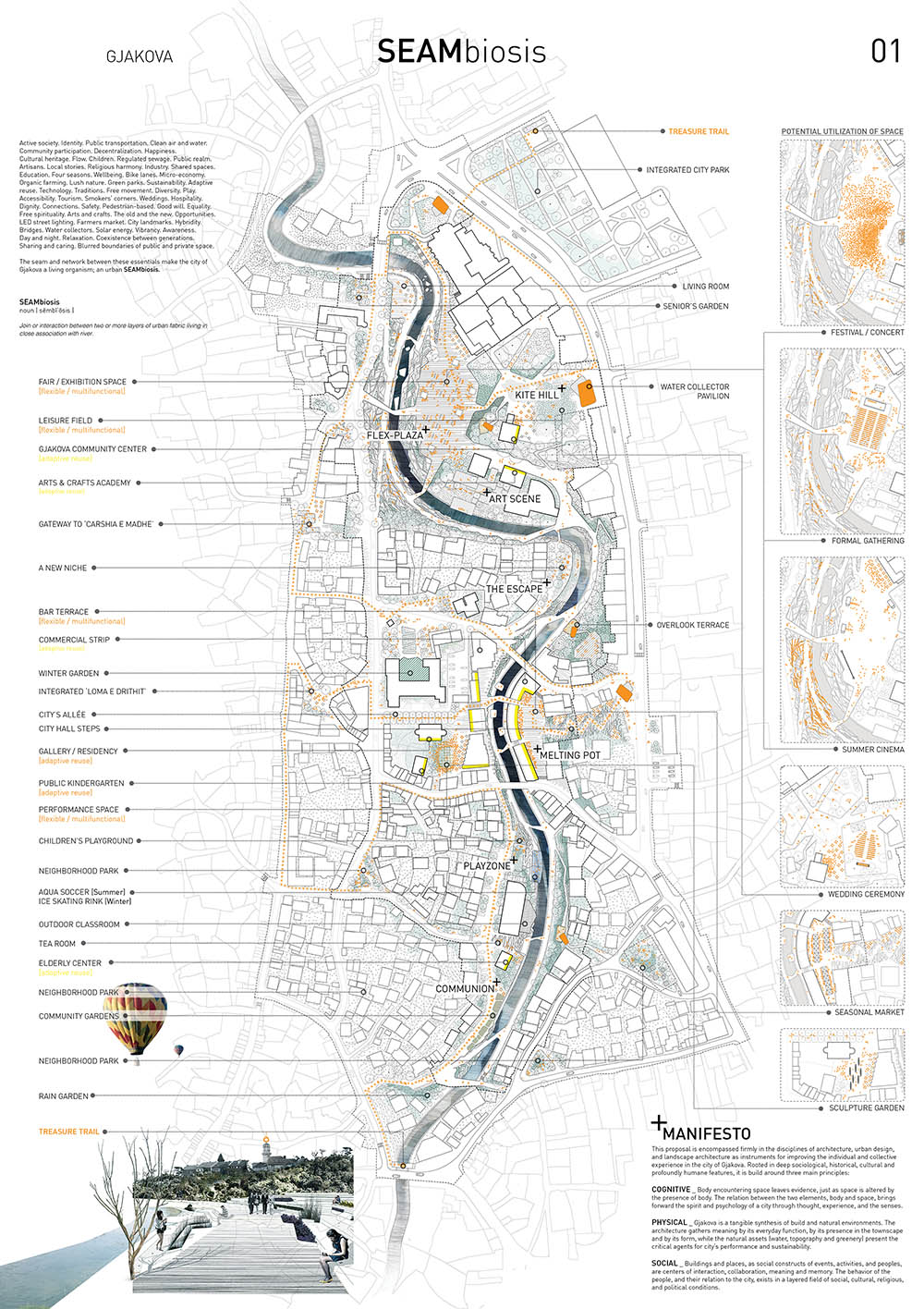

The definition of space is ethically manipulated by carefully crafting the physical city in such a way that results in freedom of movement and convenient access to all the good things Gjakova has to offer. The generated open spaces along the river function as catalysts for social activities and community engagement.
Gjakova’s synthesis of build and natural environments is achieved through making diverse spatial experiences along a linear continuous path that meanders gently along the river. In essence, the river becomes the technology and medium for proper communication within the city. It acts as a landscaped structural element for social and recreational activities for all.
Features of contemporary culture are integrated into a coherent framework that reveals the hidden layers of the city of Gjakova, facilitates interaction, and preserves the sense of community.
Active society. Identity. Public transportation. Clean air and water. Community participation. Decentralization. Happiness. Cultural heritage. Flow. Children. Regulated sewage. Public realm. Artisans. Local stories. Religious harmony. Industry. Shared spaces. Education. Four seasons. Wellbeing. Bike lanes. Micro-economy. Organic farming. Lush nature. Green parks. Sustainability. Adaptive reuse. Technology. Traditions. Free movement. Diversity. Play. Accessibility. Tourism. Smokers’ corners. Weddings. Hospitality. Dignity. Connections. Safety. Pedestrian-based. Good will. Equality. Free spirituality. Arts and crafts. The old and the new. Opportunities. LED street lighting. Farmers market. City landmarks. Hybridity. Bridges. Water collectors. Solar energy. Vibrancy. Awareness. Day and night. Relaxation. Coexistence between generations. Sharing and caring. Blurred boundaries of public and private space.
The seam and network between these essentials make the city of Gjakova a living organism; an urban SEAMbiosis.
Rooted in deep sociological, historical, cultural and profoundly humane features, SEAMbiosis is build around three main principles:
- Cognitive: Body encountering space leaves evidence, just as space is altered by the presence of body. The relation between the two elements, body and space, brings forward the spirit and psychology of a city through thought, experience, and the senses.
- Physical: Gjakova is a tangible synthesis of build and natural environments. The architecture gathers meaning by its everyday function, by its presence in the townscape and by its form, while the natural assets (water, topography and greenery) present the critical agents for city’s performance and sustainability.
- Social: Buildings and places, as social constructs of events, activities, and peoples, are centers of interaction, collaboration, meaning and memory. The behavior of the people, and their relation to the city, exists in a layered field of social, cultural, religious, and political conditions.
NETHERLAND
LEEUWARDEN
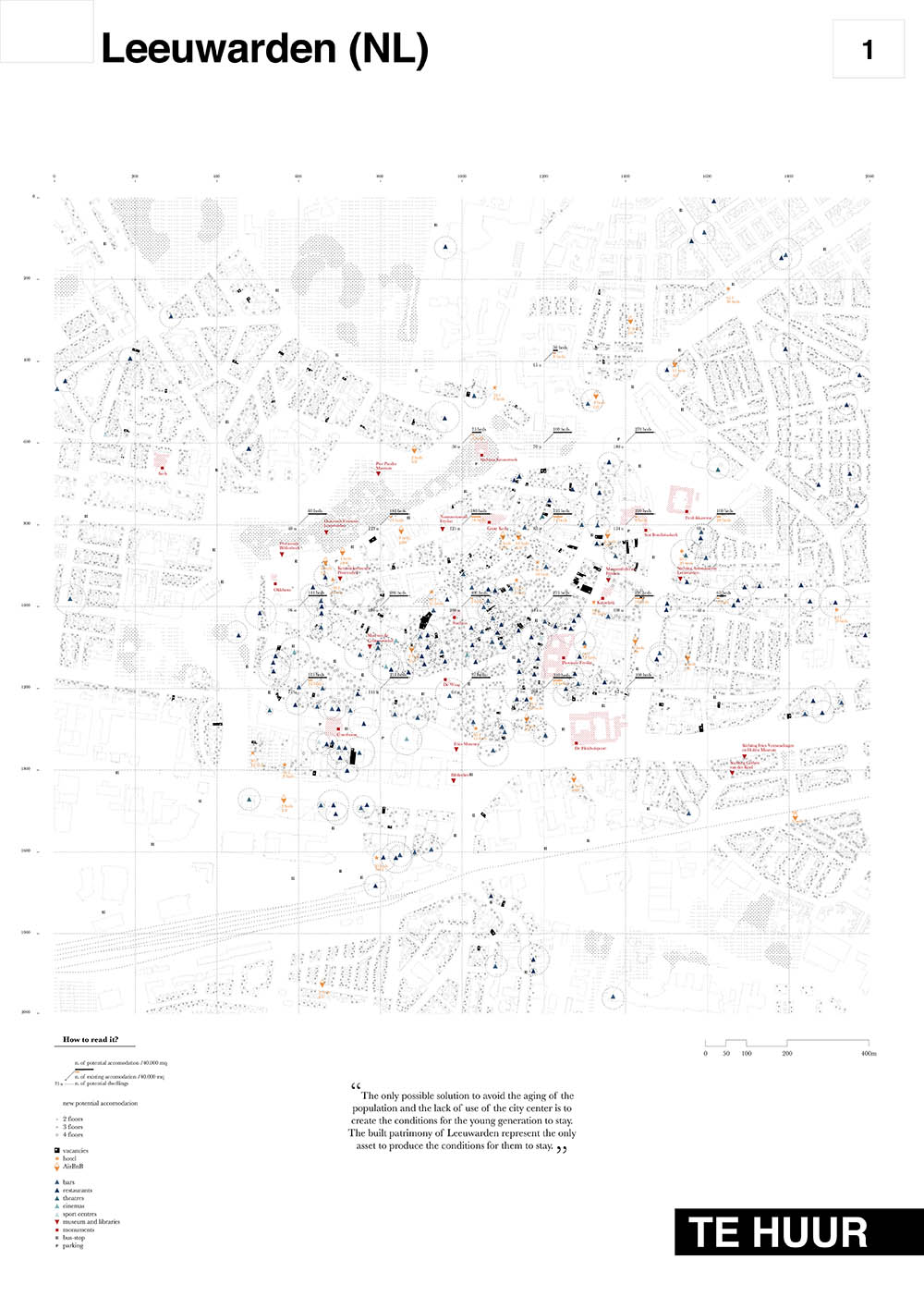
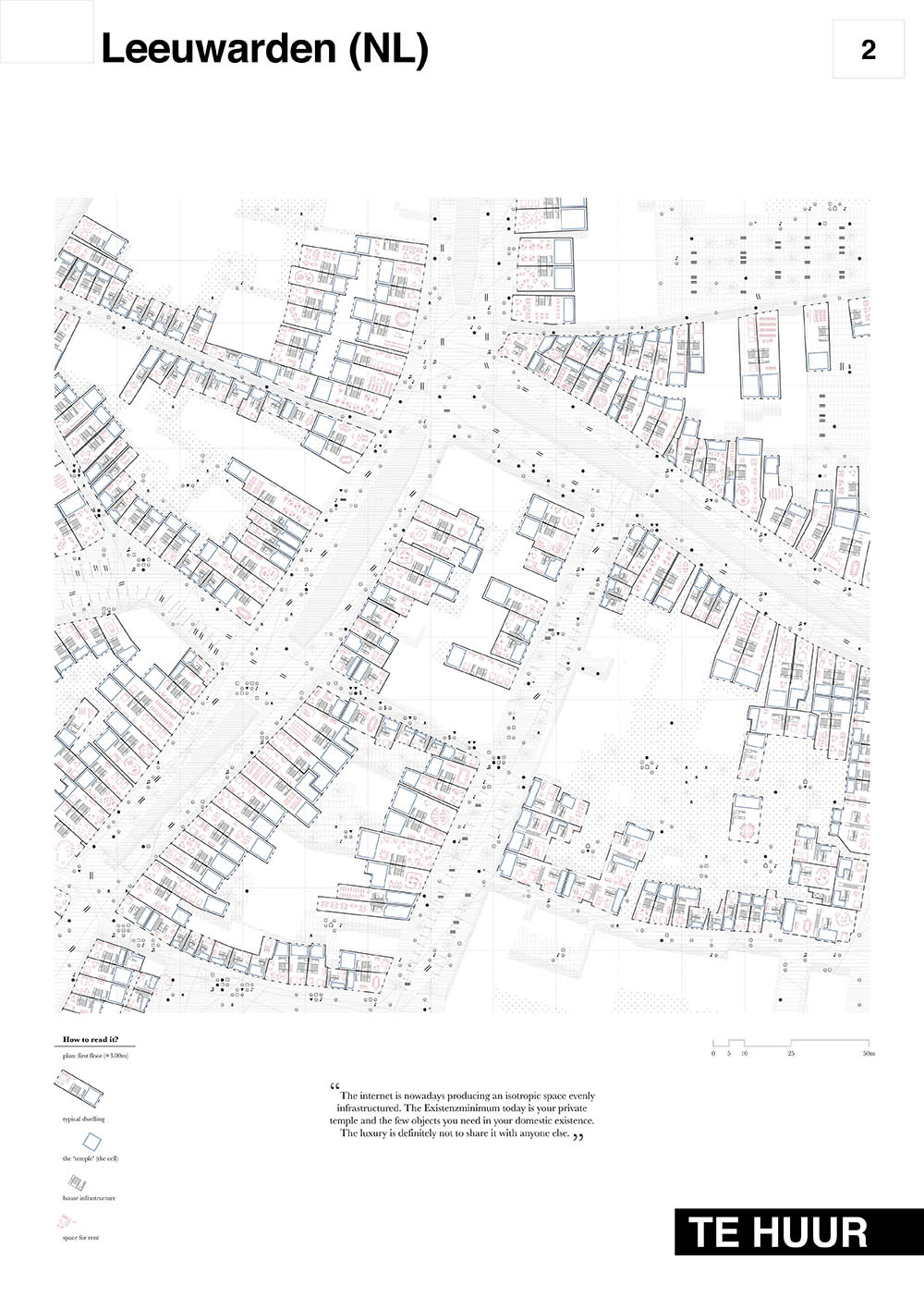
Leeuwarden is a beautiful city which doesn’t need anything else than the definition of an approach able to combine the promotion of the city center and the involvement of the citizens into this process. Through a careful investigation of the current living condition, this project proposes a bottom-up strategy which, starting from the problems related to the depopulation process of the center, will be able to reactivate the urban core. Only reviving the center, the shops will have a market, the services will have users, the tourists a context to visit.
In a city which is shrinking there is definitely no need to built new dwellings. The vacancies are a resource to define new ways to inhabit and work. The models offered by the sharing economy clearly define an alternative and more resilient pattern for the requalification of these areas. The sharing of the space is a useful tool to create the condition for start-ups, co-workings, and other programs.
The peer-to-peer economies represent as well an instrument to tackle the need of new accommodation for tourists, during the year in which Leeuwarden will be the European Capital of Culture and in the following ones.
What we expect is, in the short term, the occupation of the vacant spaces through a wide catalogue of possible activities and in the long term the stabilization of this weak system trough the energies of the inhabitants which have decided to invest in this city.
What we propose is a pragmatic scenario which considers the real conditions and needs of the inhabitants based on a bottom-up process of renovation of the dwellings and a revitalization at the level of the block. Combining the instances of the citizens and the need of an accommodation for the tourists this bottom-up strategy recognizes in the sharing of space and resources as the tool to the most important feature.
STREEFKERK
NORWAY
BERGEN
OS

The municipality of Os is currently facing a major challenge in its history: how to become a new regional and urban centre, while maintaining its own identity. This identity is mainly defined by its suburbia character (70% of households are single-family), in contrast to the nearby urban Bergen, the second most populated city in Norway.
Our proposal for europan 13 stands up for the idea that this identity should be preserved and enhanced, while it advocates a redefinition of the concept of “suburbia” in the context of a new scenario where its traditional meaning is no valid anymore. The foreseen population growth or the construction of new infrastructures in the area, coupled with the need to conceive our cities in more sustainable terms, urges the exploration of new physical and socio-economic ways of development. Through our proposal we attempt to provide an answer to those emergent conditions by suggesting a shift from ‘SUBURBIA’ to ‘OSURBIA’.
LEARNING FROM OS
Our proposal explores the ideas behind the so-called ‘suburbia’ to understand the characteristics that underpin such a distinctive identity and unique way of living. To do so, five elements or types customarily associated with ‘traditional suburbia’ have been identified on the site:
- THE SINGLE DWELLING
- THE PARKING LOT
- THE MALL
- THE FILLING STATION
- ‘SUBURBIA BEYOND THE DWELLING’
A sixth type, ‘THE STRIP’, has been defined as the element providing unity and coherence to all the rest.
By exploring the characteristics traditionally associated to these elements, the project aims at understanding the complex symbolism behind the simple forms that form those types. Thereafter, the project seeks re-appropriating these complexities to produce new meanings, while maintaining its associated symbolism.
Existing elements in Os, such as the old train station and the hall for wagons, have been preserved and redefined to adapt to new uses (i.e. art gallery, workshop and exhibition spaces); as a consequence, they have become a fundamental part of Os’ history, landscape and identity. Likewise, our proposal considers the six elements identified above as an asset rather than constrain; in order to generate unusual meaning within a recognizable architecture. Those elements are re-appropriated and re-defined within the frame of an overall urban strategy that provides unity, not only among these elements, but to the whole urban set (i.e. the existing commercial centre, the area around the Oseana culture house, existing areas of single family houses, etc.)
ØRSTA
STAVANGER
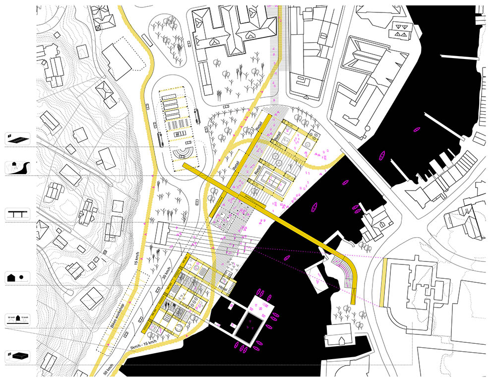
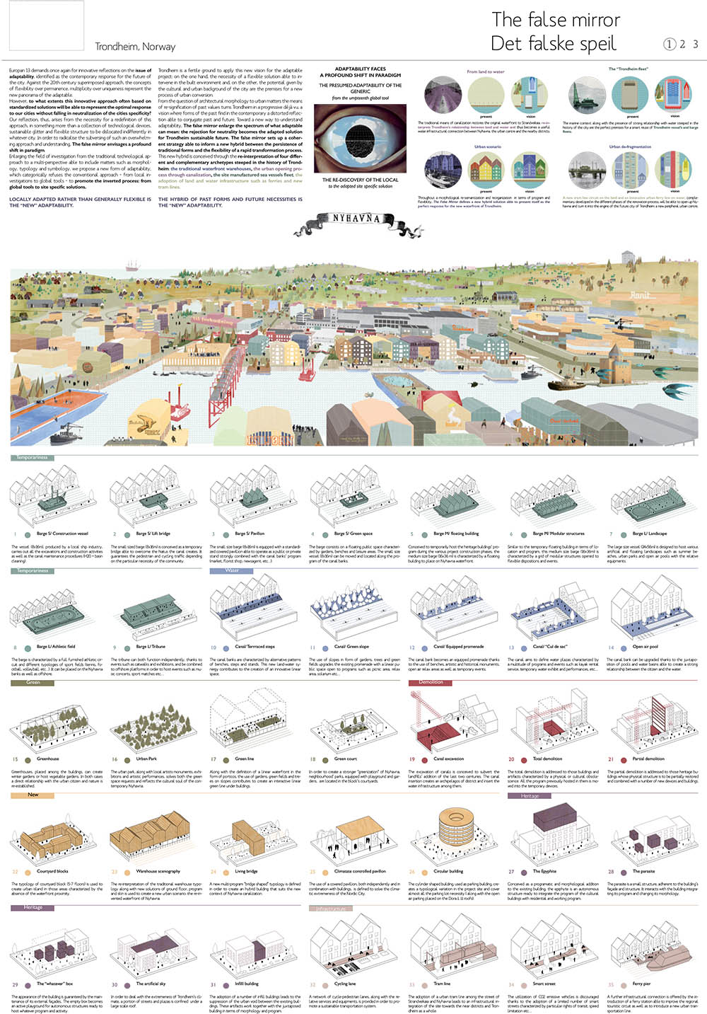
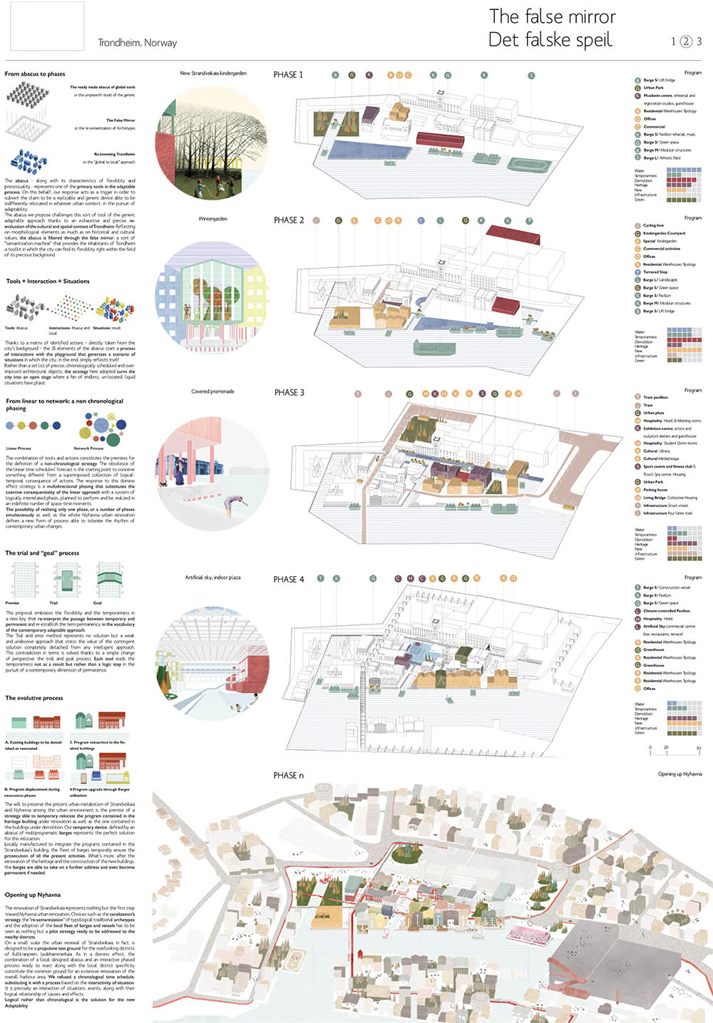
TRONDHEIM
AUSTRIA
GRAZ
LINZ
ST PÖLTEN
WIEN
The topic of this year’s Europan competition (each edition has its own topic) was “the adaptable city”. The competition’s authors decided on this topic because questions regarding city development in a time of omnipresent economic, environmental and social crisis are more and more difficult to answer.
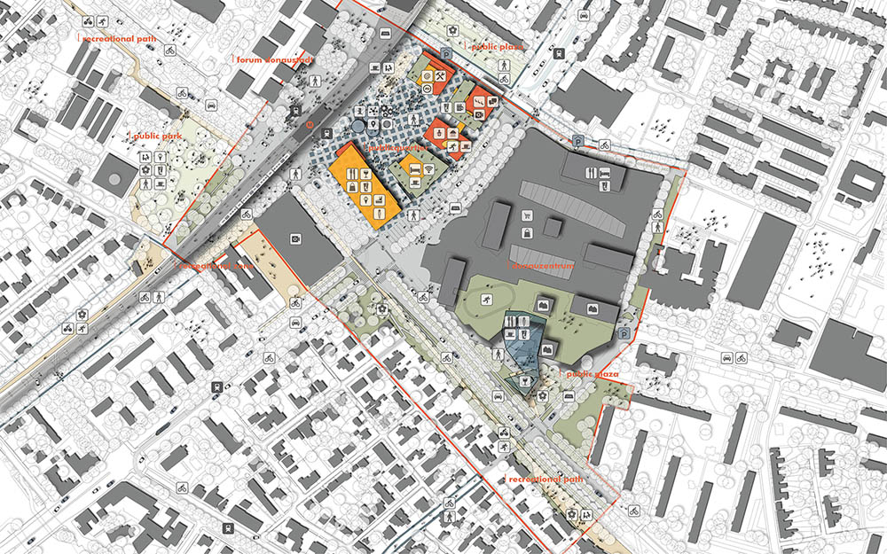
The Europan assignment in Vienna was focused on how to restructure and redesign a 10 ha area around the largest shopping centre in Vienna, and that way bring closer the goal of Vienna becoming a polycentric city.
At the moment Kagran’s public centre is actualy Donauzentrum itself, a shopping centre where all of the activities are set in a controlled physical environment, separate from other urban activities and urban settings.
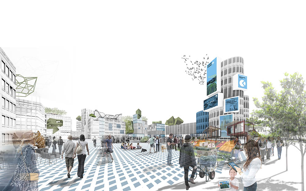
As a solution – to develop public space in the centre of Kagran – we proposed long-term and radical intervention in the structure of the whole of Kagran Centre in order to construct open space where there is the highest density of traffic and people, and where many of the users meet. We called the new centre, or part of the centre, PUBLICQUARTIER as it focuses on public use and participation.
For Kagran Centre to become a city centre in itself will be a long transformative process, but trajectories can be set today. Crucial are the changes that will engender a diverse, recognisable and accessible public space; a variety of uses and its democratic participatory administration; and goals set by Smart City strategies.
In strategic oversight it is necessary to think beyond the available open space in Schrödinger Platz as a place to develop public space, and to expect that the main public space should instead develop in a place that is at the moment occupied by the shopping centre and garages. The development of a diverse and accessible public space is possible by changing the built environment and offsetting current programmatic hierarchies. To ensure accessibility, open public space should have a position in the direct vicinity of a public transport node and in the centre of a network of pedestrian and cycling routes. It has to be structured in relation to its use and diverse users.
Publicquartier is proposed as a space that is focused on public activities and accessible programmes – an open space connected to green areas and open to be administered, organised and formed by the public itself. The new public space should be a rigorous testing ground for participatory politics. Technology and science can also be developed as communal and personal endeavours if there is an infrastructure to support such activities. In the Publicquartier there is space for such development in workshops, learning centres and co-working spaces.
We are not yet certain what awaits us after the winning ceremony in February 2016. The competition includes an opportunity for authors of the winning proposal to be actively involved in the development of the restructuring of Kagran Centre. Whatever the challenges will be, we keenly await them.
POLAND
WARSAW
PORTUGAL
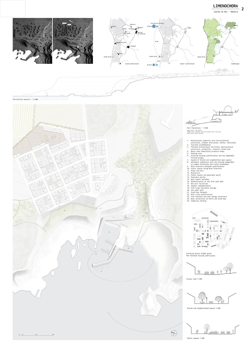
AZENHA DO MAR
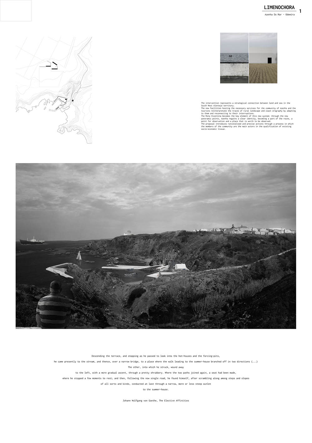
 “O que há mais na terra, é paisagem. Por muito que do resto lhe falte, a paisagem sempre sobrou, abundância que só por milagre infatigável se explica, porquanto a paisagem é sem dúvida anterior ao homem, e apesar disso, de tanto existir, não se acabou ainda” (J.Saramago, Levantado do chão).
 BARREIRO
SANTO TIRSO
SWITZERLAND
GENÈVE
FINLAND
ESPOO
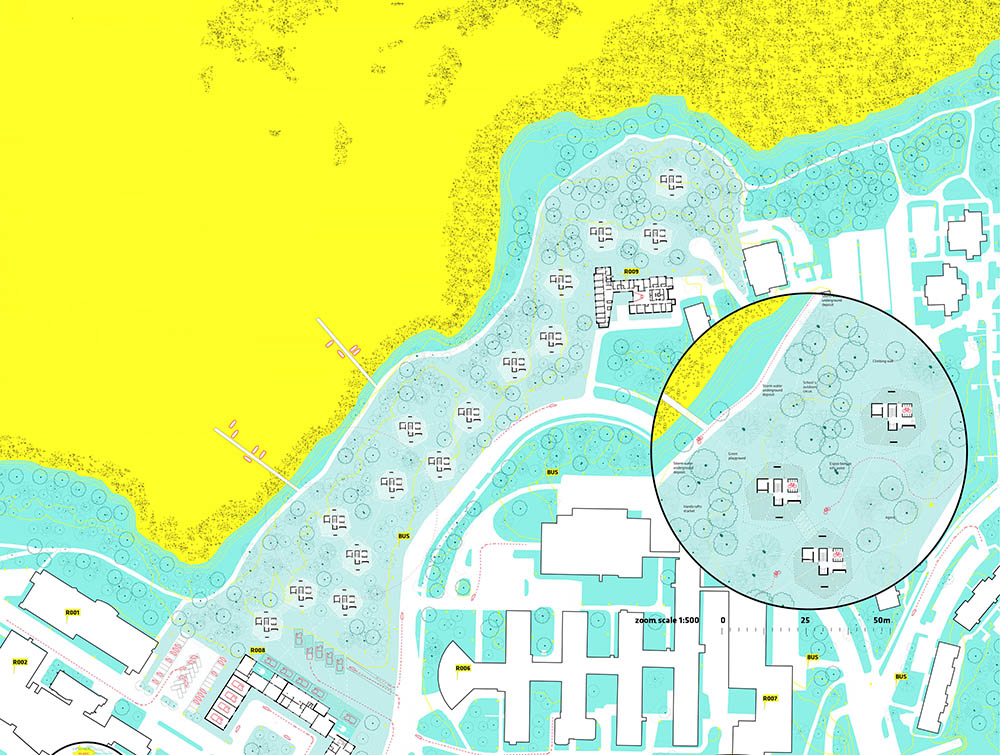
Wild Synapse is not a Project, it is an Attitude. With this proposal the architecture office formed by Borja Sallago Zambrano, Alan Cortez de la Concha, and Manuel Pinilla Fernandez has won the First Prize at Europan13 in Espoo, Finland. Last December 4th they received said award in Helsinki at the hands of Europan Finland’s organizers.
The office’s project approaches an architectural program for students and faculty at Aalto University’s campus in Otaniemi, with the particular difficulty of its insertion in woodlands bordering a EU’s protected Natura 2000 site. The jury highlighted the proposal’s sensitivity for minimizing its footprint on site, as well as its expressive construction, and the adaptability it provides to the relation between inhabitants and surrounding nature.
The negotiations for the project’s future construction are expected to begin in the coming months.
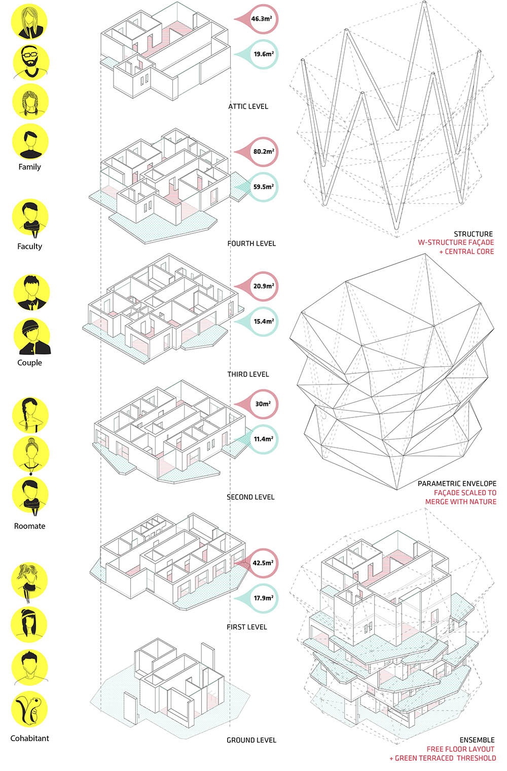
JYVÄSKYLÄ
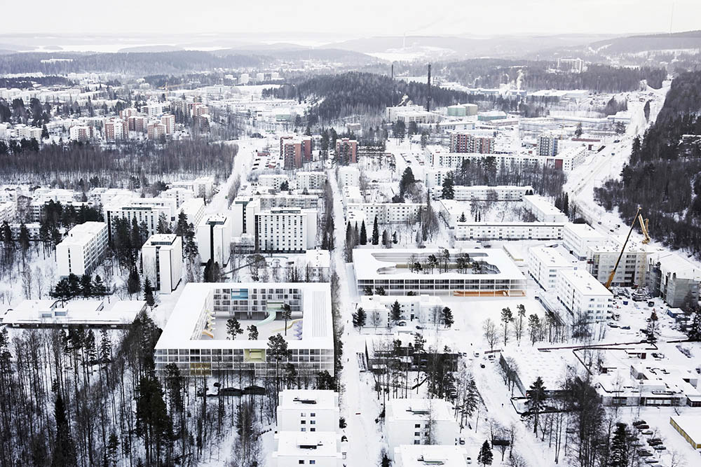
The project includes a new urban plan and addition of two mix-use housing blocks for a part of the modernistic neighbourhood called Kortephohja in Jyväskylä, a medium-sized town (135.000 inhabitants) centrally located in Finland.
The challenge of the project is how to create an attractive local centre whereby the physical buildings themselves form the catalyst for the social integration. Whereby communities become self-reliant and self-organising and whereby buildings form small villages in a network that we call the city.
We propose to invert the classic modernistic scheme of the original urban scheme. It is the public space that shapes the buildings in stead of the other way around.
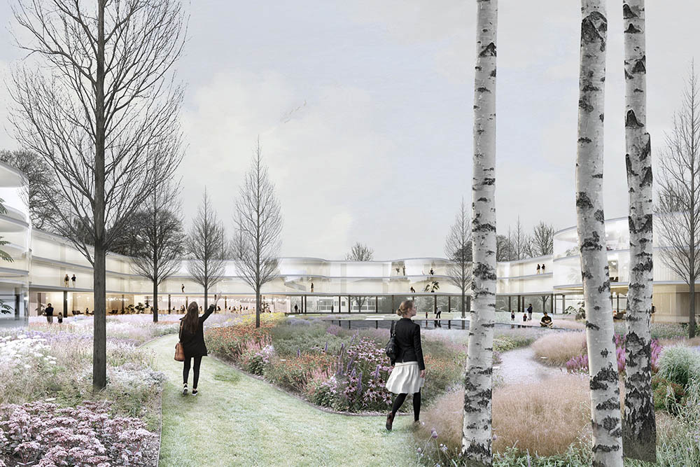
In 1784 Giambattista Nolli drew a map of the city of Rome that was revealing. Normally plans showed the built and the unbuilt space, the private and the public. Nolli presented the enclosed public spaces, such as the interior of the Pantheon, as open civic spaces. For a community exactly these open and shared spaces offer inhabitants a mutable appropriation.
The three Student Village residential buildings will be replaced by one 4-5 story student building enclosing a communal square. On every level the communal corridor is interrupted by the shared ‘Nolli Gardens’, breaking the long vista, and adding surprise and social interaction to the common space. These spaces are programmed with a collective dining room with kitchen, winter garden, lounge area, library, sauna etc.
The building for the elderly is a 3 story building that encloses a square on which a new supermarket and restaurant will be located. This ensemble will create the central block for the neighbourhood. All the apartments have a double orientation, facing both the street and the communal space that doubles as the access to the apartments.
SEINÄJOKI
Project by: Tapio KANGASAHO & Jonna HEIKKINEN
SWEDEN
LUND
The existing industrial complex has been deconstructed and partly opened up to the public. Pathways and small scale urban plazas have been added connecting it to existing and new urban fabric. It has been filled with more office space, restaurants, art shops, marketplace, a makerspace and housing.
NACKA
“ Lucker ”